Facilmap: Difference between revisions
Created page with "If you have anything new that could be relevant for the Biketour, you can put it on the map. click add in the menu (top-right corner) choose between the different ty..." |
|||
| (6 intermediate revisions by 2 users not shown) | |||
| Line 1: | Line 1: | ||
=Using facilmap= | |||
===If you have anything new that could be relevant for the Biketour, you can put it on the map...=== | |||
1. Click on "add" in the menu (in the top right corner). | |||
[[File:facilmap-add.png]] | |||
2. Choose between the different types, depending on what you are adding. (useful information without a physical place can be added as well - normally we put it in the sea) | |||
3. Put the marker wherever your beautiful, interesting or delicious thingy is. (Doesn't need to be a precise location, if you don't know it.) | |||
4. Now a window appears where you can fill out different fields. (Self explanatory, no?) Be aware when you put private information (like somebody's name or a phone number) that this pad might be shared with many people or even on our website. | |||
If you | 5. If you add a project that you know already and it was confirmed that they can host us, you can already mark the project with a "positive response"(and you can add your name into "who is in contact"). | ||
[[File:facilmap-fields.png]] | |||
===If you want to take over project contacting...=== | |||
1. Click on a blue marker - click edit - on the 'status' box , change type to 'assigned but not contacted' or "contacted' - put your name in 'who is in contact' box. | |||
2. Go to https://mail.ecotopiabiketour.net/ (user: 2018@ecotopiabiketour.net, ask us directly where to find the password). | |||
3. Write an email to the project (using this template here - https://pad.rankenste.in/p/email-template) filling in or deleting details as necessary. | |||
4. Change marker to 'contacted' and add your name. | |||
===If you want to plan a route...=== | |||
1. You can create new routes from one point to another by clicking on "Add" and "Routes" in the menu. It will switch you to the routing mode. Next to the search field using existing markers as start or end points coordinates or search results and then see for example how many hills we will cycle down in the elevation plot. | |||
2. You can change the route by clicking on it and then on "move". Then you drag the points around to change it. | |||
[[File:facilmap-drag-route.png]] | |||
3. You can change information or the type of the route by clicking on "edit". | |||
==Map styles== | |||
The style of the map can be changed in the menu under "map style". For example the OpenCycleMap and the OpenTopoMap styles are good for seeing the topography and maybe the Hike&BikeMap style is good for seeing the roads. If one of the styles doesn't work, then you can choose another one. If you need to look at the satellite picture or the "street view", you can directly go in the very bottom of the "map style" to another online map. | |||
You can switch on and off marker types and routes by clicking on their name in the list of marker types on the right side. (It only appears if you have no marker details open.) | |||
If you access the map through an admin link, there is also the option to change or add marker types. | |||
If you want to create your own editable map, just type into the address box "https://facilmap.org/WHATEVER-you-LIKE-to-CALL-it" | |||
[[Category:IT Infrastructure]] | |||
If you want to create your own editable map, just type | |||
Latest revision as of 21:13, 7 March 2018
Using facilmap
If you have anything new that could be relevant for the Biketour, you can put it on the map...
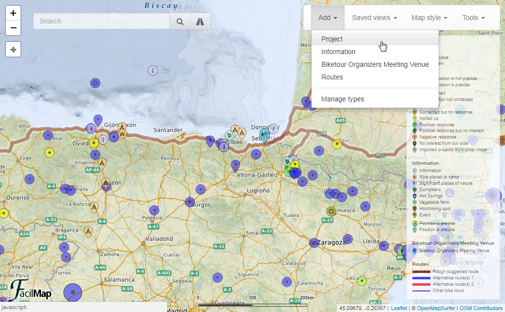
1. Click on "add" in the menu (in the top right corner).
2. Choose between the different types, depending on what you are adding. (useful information without a physical place can be added as well - normally we put it in the sea)
3. Put the marker wherever your beautiful, interesting or delicious thingy is. (Doesn't need to be a precise location, if you don't know it.)
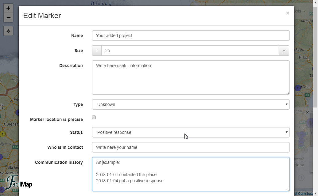
4. Now a window appears where you can fill out different fields. (Self explanatory, no?) Be aware when you put private information (like somebody's name or a phone number) that this pad might be shared with many people or even on our website.
5. If you add a project that you know already and it was confirmed that they can host us, you can already mark the project with a "positive response"(and you can add your name into "who is in contact").
If you want to take over project contacting...
1. Click on a blue marker - click edit - on the 'status' box , change type to 'assigned but not contacted' or "contacted' - put your name in 'who is in contact' box.
2. Go to https://mail.ecotopiabiketour.net/ (user: 2018@ecotopiabiketour.net, ask us directly where to find the password).
3. Write an email to the project (using this template here - https://pad.rankenste.in/p/email-template) filling in or deleting details as necessary.
4. Change marker to 'contacted' and add your name.
If you want to plan a route...
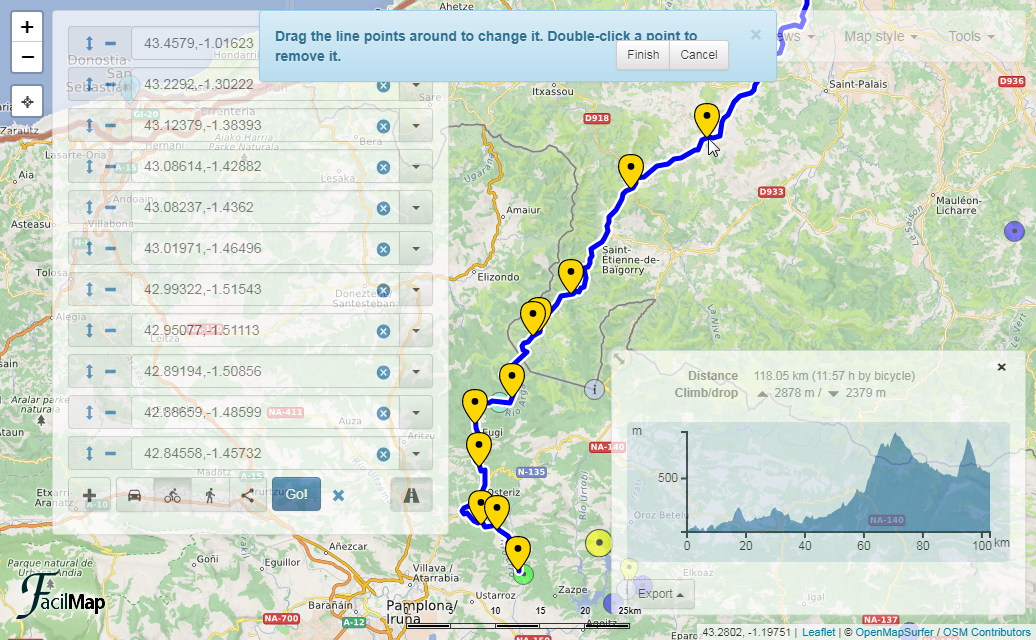
1. You can create new routes from one point to another by clicking on "Add" and "Routes" in the menu. It will switch you to the routing mode. Next to the search field using existing markers as start or end points coordinates or search results and then see for example how many hills we will cycle down in the elevation plot.
2. You can change the route by clicking on it and then on "move". Then you drag the points around to change it.
3. You can change information or the type of the route by clicking on "edit".
Map styles
The style of the map can be changed in the menu under "map style". For example the OpenCycleMap and the OpenTopoMap styles are good for seeing the topography and maybe the Hike&BikeMap style is good for seeing the roads. If one of the styles doesn't work, then you can choose another one. If you need to look at the satellite picture or the "street view", you can directly go in the very bottom of the "map style" to another online map. You can switch on and off marker types and routes by clicking on their name in the list of marker types on the right side. (It only appears if you have no marker details open.) If you access the map through an admin link, there is also the option to change or add marker types.
If you want to create your own editable map, just type into the address box "https://facilmap.org/WHATEVER-you-LIKE-to-CALL-it"


