Map 2007: Difference between revisions
Jump to navigation
Jump to search
links & participation updated |
autoroute maps |
||
| Line 2: | Line 2: | ||
==General== | ==General== | ||
===Autoroute=== | |||
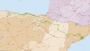
[[Image:BT07bcnesc.gif|thumb|none|[[Barcelona]] to [[Escanda]]]] | |||
* From [[Barcelona]] to [[Escanda]] | |||
** | |||
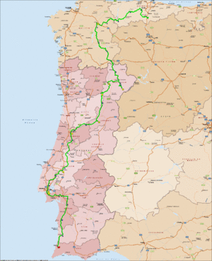
[[Image:BT07esceco.gif|thumb|none|[[Escanda]] to [[Ecotopia]]]] | |||
* From [[Escanda]] to [[Ecotopia]] | |||
** | |||
===WEB=== | |||
[http://www.tagzania.com/tag/Biketour+2007 web] | [http://www.tagzania.com/tag/Biketour+2007 web] | ||
[http://www.tagzania.com/kml/tag/Biketour+2007 3D] | [http://www.tagzania.com/kml/tag/Biketour+2007 3D] | ||
Revision as of 01:00, 6 April 2007
Maps
General
Autoroute


WEB
Spain
Portugal
Participation
The idea is to make the route decision a collaborative process, so making sure
that everyone understands and visualizes all the places is a key factor.
Here it's described how to see the map so far and contribute on it
Basically it can be done by associating tags with coordinates on a map. This is a very cool service provided by Tagzania
So far the map looks like this (at the web service page)
but let's show how it can be done , just seeing the maps
- Let's start with a simple point:
- In each item (position) you have it's own page, with much information, like about the nearest points, tags, and other users
- and links for seeing that same point "drawn" on other maps or even in 3d
- For example: the start place at Barcelona own page is like this
- Because we added tags to his point we can opt to see also all the other points with the same tag
- For example: all points with the tag Spain
- Then we can merge tags
- For example: the places of biketour AND 2007 : this
- Then you can view all the results on 3d
- with GoogleEarth by clicking the orange kml button
To participate and add points:
- You should register
- by going here
- Then you can always add a point in the maps of already existing points
- you can search for place names in different ways
- in the same website, top right
- at http://www.geonames.org
- here http://nona.net/features/map/
- or here in a roadmap service http://www.multimap.com
- on the last 3, cause you are out of tagzania, you'll need a "trick" for adding the points
- then you should fill the fields with something like:
- Title: name of the place
- Description: when (date) and others important info
- Tags (separated: it's important that we use the same, as it will be the "binding" factor, so:
- Ecotopia Biketour 2007 - they're a must
- country as in:Spain
- month as in:June
- other relevant factors like: MainPlaces , sleep , restday
- after adding the point it will be automatically available on all the maps that use one or more tags like the ones you picked